




- Subjects >
- Geography >
- Key stage 1 >
- Year 2 >
Unit outcomes
Pupils who are secure will be able to:
- Identify and locate characteristics of the UK on a map.
- Identify human and physical features.
- Locate human and physical features on a world map.
- Explain the difference between oceans and seas.
- Name and locate the five oceans on a world map.
- Use an aerial photograph to draw a simple sketch map.
- Collect data by sketching findings on a map and completing a tally chart.
- Present their findings in a bar chart.
Lesson 5 involves fieldwork in the local woodland or on school grounds (choose an appropriate green space such as the school field if it is not possible to visit a woodland area.) It is important to risk-assess the proposed route taking into account any relevant school risk assessment policies and procedures. Please be aware that lesson 5 may take longer than 1 hour.
Lesson 2 requires a device (one between two).
Suggested prior learning
Would you prefer to live in a hot or cold place?
Get started
Lessons
Lesson 1: What are some of the UK’s amazing features and landmarks?
Lesson 2: Where are some of the world’s most amazing places?
Lesson 3: Where are our oceans?
Lesson 4: What is amazing about our local area?
Lesson 5: Why are natural habitats special?
Lesson 6: How can we look after natural habitats?
Optional sustainability lesson: How can our journey to school help the environment?
Key skills
- Locating all

This content is for subscribers only. Join for access today.
Key knowledge
- To be able to
This content is for subscribers only. Join for access today.
Key vocabulary
aerial photograph
capital city
This content is for subscribers only. Join for access today.
Equipment list
Equipment needed across all lessons in this unit.
This list does not include equipment which is usually readily available in the classroom (e.g pencils, A4 paper etc)
 Download
Full equipment list for the subject
Quantities marked × will update. Items without quantities are unaffected
- Atlas ×15
- Digital device (internet-enabled) ×15
- Six photographs of human and physical features in the local area (this could include: a church, a park, a shop or a river - six per table group) ×8
-
A3 colour aerial photographs of the local area, including either the school or a local feature recognisable to the children
×8 -
An OS map of the local area
×15 - PE hoops ×15
- Magnifying glass ×15
- Clipboards ×15
The equipment below is optional
- Identification sheets (choose relevant sheets found: Tree tools for schools from the Woodland Trust) ×30
This content is for subscribers only. Join for access today.
Related content
Unit resources

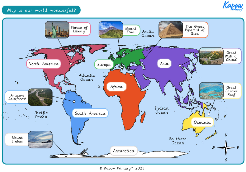
Knowledge organiser: Geography – Y2 Why is our world wonderful?
Aimed at pupils, two pages providing key facts and definitions from the unit "Why is our world wonderful?".

Vocabulary display – Geography Y2: Why is our world wonderful?
A display version of the vocabulary from the unit ‘Why is our world wonderful?’.
Subject resources
This content is for subscribers only. Join for access today.
Cross-curricular opportunities
English: Spoken language
Art and design
Science: Living things and their habitats
British values: Tolerance of those with different faiths and beliefs.
Build on the learning
What is it like to live by the coast?
Get started
