


Unit outcomes
Pupils who are secure will be able to:
- State that the UK stands for the United Kingdom.
- Point to each country in the UK on a map when prompted.
- Verbally identify features within the school grounds.
- Use and respond to directional language.
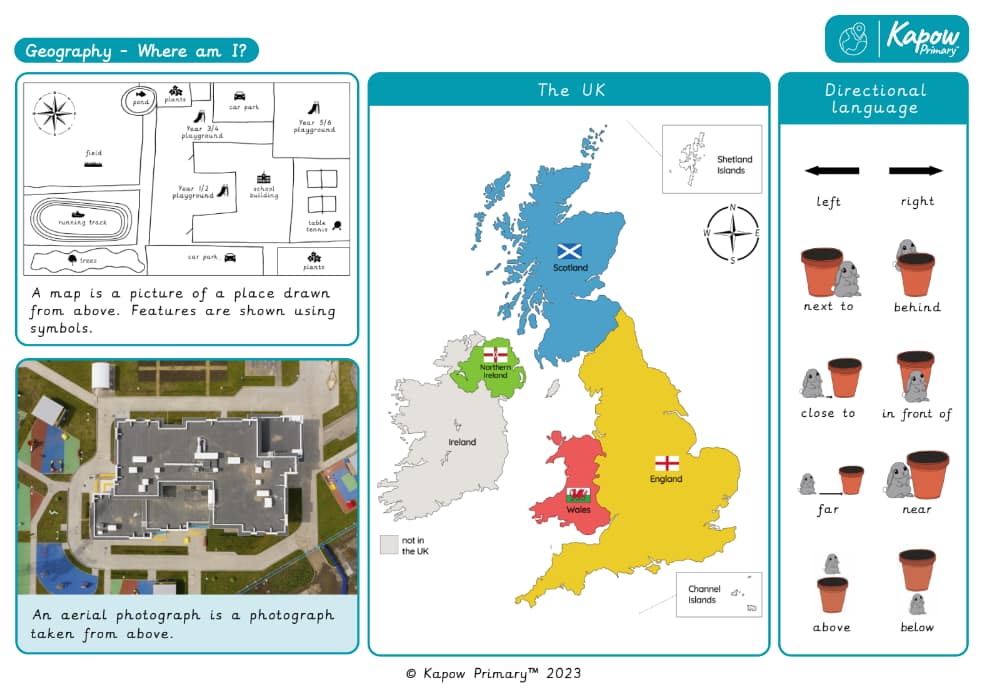
- State that an aerial photograph is taken from above.
- Recognise some familiar features in aerial photographs.
- Explain that symbols show features on a map.
- Add symbols to a map.
- Identify how places on the school grounds make them feel.
Lessons 2 and 6 require a device to take photographs (one per group).
Suggested prior learning
Y1/2 (A): What can you see at the coast?
Get startedLessons
Y1/2 (B): Lesson 1: Where do we live?
Y1/2 (B): Lesson 2: What is a feature?
Y1/2 (B): Lesson 3: What is a map?
Y1/2 (B): Lesson 4: What is an aerial photograph?
Y1/2 (B): Lesson 5: How are features shown on a map?
Y1/2 (B): Lesson 6: How do places in school make us feel?
Key skills
- Recognising some physical features

This content is for subscribers only. Join for access today.
Key knowledge
- To know that the
This content is for subscribers only. Join for access today.
Key vocabulary
aerial photograph
aerial view
This content is for subscribers only. Join for access today.
Related content
Resources
Unit resources

Geography
Knowledge organiser: Geography – Y 1/2 Where am I?
Aimed at pupils, a single page which gives key facts and definitions from the unit "Where am I?".
Geography
Vocabulary display: Where am I?
A display version of the Vocabulary from the unit 'Where am I?'
Subject resources
This content is for subscribers only. Join for access today.
Cross-curricular opportunities
English: Spoken language, reading – comprehension
Music
Computing
Build on the learning
Y1/2 (B): Would you prefer to live in a hot or cold place?
Get startedPopular content
- Geography: Curriculum portal
- Geography: Curriculum information
- Geography subject leader hub
- Geography: Fieldwork guide
- Geography: Staff Presentation
- Webinar: An introduction to geography
- Geography: Progression of concepts —mixed-age
- Ace your role as a D&T subject leader
- Ace Your Role As A Music Subject Leader